


Santo Tomas
It is the beach and access to the sea for the municipality of Es Migjorn Gran, the last town in Menorca to acquire the status of municipality after separating from Es Mercadal.
The beach of Santo Tomas, which gives its name to the tourist development, is quite long, a bit narrow in some stretches, but has fine sand. The winding access road is one of the most beautiful on the island and runs through a forest of large Mediterranean pines.
The development, one of the veterans of tourism, has settled in little by little, leaving hotels and large residential complexes at the water's edge—especially aparthotels—and further from the coast, in the pine forest, the chalets. It has all the services of a developed tourist area, but remember that it is seasonal tourism; the vast majority of establishments are only open in summer, from May to October.
The three beaches in this area, Santo Tomas, San Adeodato, along with those in the Son Bou area, form the longest and straightest beaches on the entire island, and the flattest and gentlest stretch of Menorca.
On this coast of the island, the terrain descends towards the sea more gently than on the north coast, where cliffs dominate most of the route, falling abruptly into the sea, interrupted only by the coves that form at the end of the barrancos, some of them ending in dunes. However, the south coast of the island—given that this stretch of the territory is not directly punished by the force of the tramontana wind—has come to define the geographical difference between the north and south coasts.
Description of the coastal profile:
The south coast of Menorca descends gently; even where there are cliffs, they are not as high as on the north coast. The interior of the barrancos becomes wider, the hills move away from the coast, and the land descends little by little, leaving the barranco at a considerable distance from the water and revealing wide valleys and very open areas. There are exceptions, of course, as this ends upon reaching the beaches of Binigaus and San Adeodato, where you encounter small cliffs of two or three meters at first, rising in some sections and alternating clay walls with rocks that reach the beach itself, forming a slope of two to five meters in height and leaving a narrow strip of sand. But don't be fooled; the narrowness of the beach is precisely what makes them much more attractive. Seeing the coves and some rocks shared halfway between the sea and the beach has a special beauty and gives the sensation that the place is more unspoiled, more pristine, almost as if we were naufragost
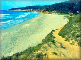 on a tropical island in a remote part of the world. You must experience this sensation, you must get to know Binigaus.
Toward the other side, upon finishing the beach of Son Bou, the change is much more abrupt; right at the end of the beach, there is a mountain massif that gains height quickly, and thus the most classic profile of the Menorca coast is repeated: cliffs, interrupted only by coves, mostly the end of a more or less narrow barranco flanked by significant rocky walls. From here on, the coves are: Cala Llucalari, Cala'n Porter, Cales Coves, Cala Canutells, and other small coves until reaching, now at last, a flatter and more open area, Punta Prima, where the territory descends once again until S'Algar in the outskirts of the mouth of the Puerto de Maó.
All these areas are included and described in these itineraries.
Binigaus:
It is the central beach of a group of three consecutive beaches found in the vicinity of the urbanisation and beach of Santo Tomás. It is also often called Binicodrell beach, named after the islet that separates it from the third beach, San Adeodato. However, to tell the truth, the vast majority consider them as one and refer to it by the name of the urbanisation, Santo Tomás. With fine sand, the beach is narrow, and its width varies from one season to another, depending on the tramontana winds in winter.
The edge of the Santo Tomás beach is determined, in addition to the sea, by hotel establishments and other tourist services right on the boundary of the beach, and then, when the dwellings of the urbanisation give way to the natural territory, the boundary is marked by the fields of crops that follow 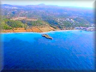 immediately after the beach line, and then the clayey soil zone.
It has a beach bar right at the arrival point of the road coming from Es Migjorn Gran, which is the only road to reach it by car. At that point, there is a small roundabout; to the left is the urbanisation of Santo Tomás, and to the right is a car park and the exit of the path to the unspoiled beaches of Binigaus and San Adeodato.
Just as you reach the entrance of the barranco that leads to the Cova des Coloms—that is, shortly after passing the islet of Binicodrell, which can be seen in the aerial photograph—there are small trenches, one of many on the Menorcan coast, used by militias for coastal defense and camouflaged underground in the mound of terrain. It is right here that the elevation begins and narrows the Binigaus beach, leaving in some sections only a path between the sea and the water, creating the most beautiful part of this beach.
Binigaus is an unspoiled beach, the pearl of this area adjacent to the beach and urbanisation of Santo Tomás, about a thousand meters away. Walking along the coast, it opens up into the barranco that forms it, giving rise to a beautiful and deep beach that also has a large forest area on one of the slopes, ideal for relaxing or snacking during the hours when the sun is strongest, or simply going up to see the views. Although this more secluded spot was originally chosen by naturists, the pressure of crowds is pushing them a little further along the same coast to other smaller but equally charming coves. Given that the cliff is made of reddish terracotta, it is common to see them taking clay baths, adopting an intense dark reddish color that lightens as the mud dries.

Excursions:
Cova des Coloms, the most famous cave on the island of Menorca, with gigantic proportions, as if it were a cathedral. Its dimensions are such that at any time of the year, we can find tents set up inside.
The entrance is halfway up the barranco, which, added to abundant vegetation, hides the entrance of the cave a little. Despite everything, it is easily reached as it is signposted at the entrance and by the paths that lead to the cave.
In addition to the Cova des Coloms, the barranco itself is a good excursion to enjoy the curious shapes that the landscape takes on inside it. Take the path of the Binigaus stream at the end of the beach and follow it. It can also be reached from Es Migjorn Gran; there are signs to get there.
Another excursion is in the opposite direction to the path to the Cova des Coloms, and consists of walking from Santo Tomás to Son Bou.
To do this excursion, we head to the end of the Santo Tomás urbanisation, and upon reaching the San Valentín Star hotel, if we are driving, we must leave the car parked here and take the path to the beach. Upon reaching it, we turn left and start the path, always along the coast, next to the jetty. The first thing we will find are some curious slots in the rocks; these are the peepholes of the defense trenches, built by soldiers of other times to watch over and defend the island.
After passing a short stretch of low-height cliff, we will descend with our eyes set on the great expanse of the Son Bou wetlands and thus enter the sand again.
Access:
From the main road, Me1 between Ferreries and Es Mercadal, there is a well-signposted turnoff onto the Me16 road that leads to Es Migjorn Gran. Leaving the town on the right, continue on the road, which is now the Me20, until you reach the sea, about seven km from the main road and 3 km from Es Migjorn Gran. The road is new and beautiful.
Another possibility is from the back of Ferreries. If you are coming from Ciutadella, just after passing the turnoff to Cala Galdana and at the first curve entering the town, continue straight on the narrow road that passes through the high area of Ferreries. This is the Me20 road; this route also leads to Es Migjorn Gran. The road is narrower and has many curves, but it is much more picturesque.
Once you have reached Es Migjorn Gran, from here to Santo Tomás we must take the Me18 road, which ends at a roundabout next to the beach of Santo Tomás. The roundabout is decorated with "a bird's nest".
To the left, we go directly along the central avenue of the urbanisation. On the left side, villas predominate, and on the right, hotels and blocks of apartments or aparthotels, located in front of the Playa de Santo Tomás.
Just in front of the nest roundabout, arriving from Es Migjorn Gran, to the left, there is a vehicle car park.
free.
Map of access to Santo Tomás
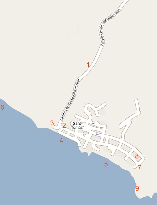
Description of the points marked on the map of the Santo Tomás area
1 - ) Me18 regional road that connects Es Migjorn Gran with the urbanisation of Santo Tomás and the beaches of San Adeodato and Binigaus.
2 - ) Entrance to the central road of the urbanisation of Santo Tomás; when arriving from Migjorn, you must turn left. Most hotels, aparthotels, and apartment complexes have their main entrance on this central road of the urbanisation. At the end, there is a free parking area.
3 - ) Public and free parking area.
4 - ) San Adeodato beach.
5 - ) Santo Tomás beach.
6 - ) Binigaus beach, an unspoiled beach one kilometer from the Santo Tomás urbanisation and the path for the excursion to the Cova des Coloms.
7 - ) End point of the road; if we are going to do the excursion to the beach of Son Bou, we must leave the car and take the beach path.
8 - ) Public and free parking for vehicles.
9 - ) Exit to Santo Tomás beach by the jetty area; just above the trenches is the path that leads us to the beach of Son Bou, about 15 to 20 minutes away.
Copyright Islademenorca.es, total or partial reproduction prohibited without written authorisation.
Photographs: Omar Mauro Banquero