


Favàritx
Parque Natural de la Albufera de Es Grao and Colom Island
 Favàritx Lighthouse:
It is currently the central area of the largest natural park in Menorca, since a few years ago the process of extending it to the area of the Puerto de Addaia was completed, which left the Cape of Favàritx and its access road in the middle of the park and as the second most visited entrance route to the most visited park on the island of Menorca.
The path that leads us to the lighthouse located on the Cape of Favàritx or Cape of Picafort is the Cf1 local road. The cape is a very pointed rocky point made of black slate rocks, which forms bays on both sides of the lighthouse.
The coast has a characteristic landscape, different from others, with cliffs that are not very high and made of slate that is very blackened when it is damp or wet, and silver-gray when it is dry, configuring one of the oldest geological terrains in the Balearic Islands. Given that Menorca is divided into two geological eras, here one can appreciate areas of both plates.
On the left side of the lighthouse, two distinct types of materials can be distinguished in the rock, in addition to long veins of intense ocher oxides, which give a special beauty to the landscape and greater interest for geology enthusiasts.
The interior areas have abundant springs, small seeps that cross the surface of the slabs with threads of water until they find an earthy mass or a crack between the stone layers, losing themselves but leaving life and greenery along their path, as if it were a small oasis.
The area of the Cape of Favàritx is very lashed by the winds, especially the Tramontana, and the waves overcome the coastal barrier formed by a pebble beach next to the lighthouse, 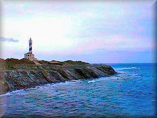 flooding an esplanade that, upon drying, forms a whitish surface known as "La Salina de Favàritx."
As we were saying, this area has several beaches of great value, and by belonging to the park, they remain undeveloped; they are on the right in a wide bay, to the right of the lighthouse.
Logically, all the beaches within the Es Grao park are pristine; here we will highlight those that are most interesting and, above all, most accessible and close to the Favàritx Lighthouse area.
Given that this zone is a natural park, protected by legislation, it has a status and management, as well as rangers. It must be taken into account that it is an ANEI (Natural Area of Special Interest), and like all ANEIs in Menorca, the entire natural environment must be actively respected. You cannot light fires, leave traces  of packaging or trash, or leave the trails or paths designated for walkers, cyclists, or equestrians if riding a horse. Remember that all of Menorca is declared a "Biosphere Reserve" by UNESCO, and therefore there is a special commitment to protect its scarce territory. Failure to follow the rules within the natural park may lead to sanctions and/or fines.
The beach of Cala Presili has fine, very dark sand and is bordered for much of its length by the cliff, followed by a stretch where the dunes descend through a small valley that gives it more width.
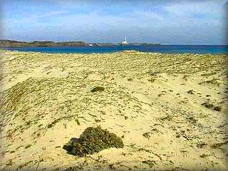
The beach of Capifort or Arenal de Morella is a few hundred meters from Presili, crossing a rock formation, "Punta de Presili," with the area behind it full of sand. Upon descending, you can see the wide beach of Arenal de Morella; it is by far the best beach of the quartet, of good dimensions with the dunes located further inland. Leaving the dunes aside, there is a wetland area of considerable size.
Playa d'en Tortuga is found at a very short distance after passing a small rise. The beach is gravelly and smaller, very dark and wild but charming and quiet. It tends to be less crowded as it is located after a larger, more open beach.
Cala Morella Nou is the furthest and least appealing of the four, as it almost never retains its sand. However, the forest behind it is the densest and an exception in the entire area: there is a rustic cottage, like something out of a fairy tale, right at the edge of the forest.
Just before arriving at the lighthouse, on the left side, there is a small pebble beach. Despite being in a wide bay, it faces north, which guarantees waves. It is not very interesting, except that it is right next to the path, ideal for those who do not like to walk or want to launch a boat into the water to explore the area.
The beaches that are after Cabo de Mossèn Vives are discussed in the “Es Grau area”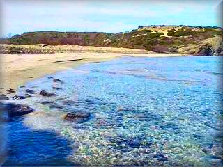 .
.
Excursions:
A couple of kilometers before the lighthouse, there are some old and somewhat dilapidated military installations with good views of much of the coast. It is interesting to walk from the batteries to the tip of Cala Caldes. In this stretch of the cliff, you can observe how large masses of earth and rock are cracked and shifting as if attracted by the sea, which will sooner or later swallow them up. If you wish, you can continue; passing Cala Caldes you will find the pearl of this stretch, the beautiful beach of S´Enclusa. Without a doubt, it is worth it, but it takes a good hour at a steady pace.
Access: (See map in this same guide)
Via the Maó to Fornells road (Me7), which starts at the end of the 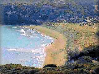 Port of Maó and ends at the junction with the Me15. Along its route, starting from the Port of Maó, it passes by the Ermita de Fátima at km 8, and just before reaching kilometer 9, a narrow path begins on the right, which is the Cf1, ending at the Favàritx Lighthouse about 8 km away.
To go to the beaches, there are two paths. One starts in the opposite direction to the cove of S´Escala, which is one thousand meters before arriving at the Favàritx Lighthouse and is the pebble beach used as a parking lot; from here, you must walk to the opposite coast of the cape and then follow the coast to reach the different beaches.
The other path starts about a thousand meters earlier, and you will see on the right bank some posts stuck into a rustic path, placed to prevent the passage of vehicles; that is the starting point. This path takes an inland direction and joins the path to the beach in about thirty minutes, leading directly to the wide part of Cala Presili.
Access map to the Favàritx Lighthouse area
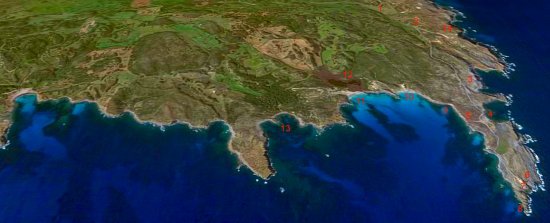
Map of the Favàritx Lighthouse area, which includes the entire coast covering the maritime limit of the "Albufera des Grao" park, that is, from the town of Es Grao to the Port of Addaya, including the central point and access to the beaches near the Favàritx Lighthouse.
Description of the points indicated on the Favàritx Map.
Me7 is the name of the road that connects the city of Maó, the capital of Menorca, and the town of Fornells.
The white dot indicates the exact point where the turn-off to the Favàritx Lighthouse is located, that is, kilometer point 8.8 of the Me7.
1 - ) Cf 1 road providing access to the Favàritx Lighthouse. The two white dots marked on this stretch indicate access points to the ruins of the old Favàritx Military Battery; the first, closest to the base of the cannons and turrets for artillery pieces, the second, just before passing some barriers with a "Cattle Guard," is the entrance to the barracks and military buildings.
2 - ) Just at the point where the entrance to the Favàritx Battery is located, there is a "Cattle Guard," and from here, you enter the specific area of the Favàritx Lighthouse.
Remember that you are in an ANEI (a natural area of special protection), the Albufera des Grao Natural Park, and therefore, you must not leave the paved tracks or paths with your vehicle or even on foot. You also cannot collect animal or plant species, or light fires, to avoid the destruction of endemic species of the park.
3 - ) This point is only of interest if you visit on a stormy day to see the waves crashing against the rocks; it also has a parking area.
4 - ) Cala des Portitxol; the beach is of average quality and is very little frequented, despite being next to the road, or perhaps because of it.
Here is the starting point of the paths that lead to the main and most beautiful beaches in the Favàritx Lighthouse area.
5 - ) Exit of the path to the other side of the Favàritx Cape; the junction is no more than half a kilometer away.
6 - ) This site, where in stormy weather it is spectacular to see the waves crashing against the living rock, is also very beautiful due to its geological characteristics.
7 - ) Es Pla, or the Favàritx Salt Flats, is a flat area almost at sea level, which floods with very little wave action and, upon drying, forms a white, vegetation-free plain due to its high salt content. Next to the salt flats, there is an area where we can leave the car.
8 - ) Favàritx Lighthouse, Favàritx Cape, or Capifort Cape.
9 - ) Cala Presili.
10 - ) Capifort Beach, there are two beaches very close by with dunes that gain height very quickly, leaving a narrow strip for the beach in some areas.
11 - ) Playa d'en Tortuga is a medium-sized beach with brownish sand, wide, and with a large dune area, in addition to the wetland of the Morella Lagoon.
12 - ) Location of the Morella Wetland; in the summer period, it usually dries up, making it difficult to locate its position.
13 - ) Cala Morella Nou, is a beach of small, flat stones, almost joined, only separated by a rocky spur; the area is not very suitable for swimming or sunbathing, and behind it, there is a very dense pine forest.
14 - ) Location where the largest artillery pieces of the old Favàritx military battery were found, but, a kilometer away on both sides and next to the coast, you can see remains of the military installations, now abandoned.
15 - ) Cala Caldes
16 - ) Cala de s`Esclusa
17 - ) Illa Petita d´Addaia
18 - ) Illa Gran d´Addaia
19 - ) Location of the Puerto de Addaya, at the end of the urbanized area
20 - ) Addaia Urbanization, the point where the Torre de Addaia is located,
Copyright Islademenorca.es, total or partial reproduction prohibited
Photographs: Omar Mauro Banquero