


South Coast of Sant Lluís
Punta Prima, Biniancolla, Binibeca, Binissafuller, Cap d´en Font, Biniparratx, Binidalí, and in Maó, Es Canutells.
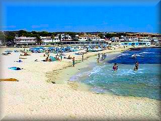 Punta Prima:
The beach at Punta Prima is a sandy area of considerable size and quite deep, well-known given its location, easily accessible, with regular bus services, well-marked access points, and a short distance from Sant Lluís or even Maó.
The beach at Punta Prima is the center of the residential area that surrounds it as it grows. The beach has a gentle slope, since the channel formed by the coastal sandy area and the islet Illa de l'Aire (which has a lighthouse) is a key point, given its isolation at one of the ends of the island of Menorca and it is a mandatory passage for most ships that connect Menorca with the Peninsula or the other islands of the Balearic archipelago.
The islet, distant about 700 m, also has a sandy bottom, reducing the force of the Xaloc wind that hits the beach head-on. The beach at Punta Prima has fresh-water shower facilities and emergency rescue teams with inflatable boats in case of accidents at sea.

The residential area of Punta Prima mainly consists of chalets and has several hotels, some of which are very large. The constructions, given that they are mostly chalets, are quite spread out. It has seen strong expansion in recent years, which guarantees the tourist a wide variety of services with a very varied complementary offer, mostly during the summer season. It has large parking areas, supermarkets, sale of beach items, car rental, as well as nautical and recreational services, in addition to a very wide gastronomic offer, displayed in a good number of restaurants and complemented by leisure and shows, especially on the terraces of the large hotels.
Excursions: If you have a boat, we can make a visit to the Illa de l'Aire located just in front of the beach about 700 meters away and see the lighthouse, but above all the large colony of black lizards, “Sargantanes negres”, unique due to their characteristics in the Balearic Islands and an endemic species.
Binibeca Beach:
The beach at Binibeca is one of those places that few fail to visit. With several residential areas near it, they have increased the influx of bathers, adding to the already traditional influx of Menorcans, but it has not lost ground; it has not been invaded, and it is not even seen to be fenced in by chalets or blocks of apartments and hotels on the beachfront, maintaining its natural area almost intact.
The beach at Binibeca is very deep with fine sand, and behind it there is a small pine forest, ideal for 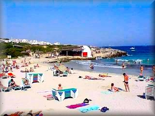 resting from the sun when it gets too strong. It has a picnic area, perhaps one of the first that had fixed installation on the island's beaches, which retains the appearance of a fisherman's hut of yesteryear, giving it a postcard image next to the beach, where we can eat with the best views of the cove and the beach, under a reed roof and sturdy log tables.
Fisherman's village, Binibeca Vell
It is a mandatory stop, as well as recommended, if you are in this area or staying in the western part of the island of Menorca.
A visit to the town of Binibeca is recommended due to the curious nature of the village, which is now intended for tourist accommodation. After the beach and at dusk, take a quiet walk and enjoy the haven of peace, passing through the little white houses and the infinity of nooks and crannies, which are like those in children's stories.
The village has been built on the basis of the old fishermen's village next to the small pier; it has a church with a curious bell tower, a tiny square, and a promenade through the area that faces the sea.

While you are at it, on a walk through Binibeca Vell, we must finish the excursion by taking a tour of the shops in the shopping center or enjoying the restaurant services; even in the shopping area, you will find leisure offers.
The Binibeca shopping area, built later, is a place of more classic constructions in its dimensions but maintaining a style and Mediterranean influences of the constructions. A lot of wood has been included in the balconies and floors, which makes it more attractive and well justifies another walk.
Binibeca has a good number of hotel beds and more in apartments or chalets intended for seasonal tourism, restaurants, bars, beach accessory shops, souvenirs, gift items, and car and motorcycle rentals.
Excursions:
On the right side there is a large cave with an immense "bufador" (blowhole); it is an interesting place for a walk.
To the left of the Binibeca beach, 500 meters away, is a hamlet, Cala Torret, with a diving center. It might be a good time to dive or take a course; it also has a jetty and a crane. In the Torret square within the apartment complex, there are a number of services: a supermarket, a restaurant, vehicle rental, and souvenirs.
 Cala Biniancolla:
It is a small area where the mooring area and the fishermen's boat huts stand out, facing the breakwaters of the jetty which ends in a pebble beach of little value for swimming. It is surrounded by a small housing development. Midway between the beach of Binibeca and Punta Prima, on the upper part, there is a hotel, and next to the jetty, a restaurant with a large terrace and views of the cove. Not far away, there are other gastronomic services highly appreciated by the residents, who are mostly from Menorca. Activity is scarce and very quiet; the vast majority of services must be sought in the larger neighboring housing developments.
Binidalí is a small but charming cove with a fine sand beach. The cove has an entrance of about 200 meters, and at the end, the barranco narrows increasingly. The cove has no services, but the housing development is not far from the cove.
Cala Biniparratx:
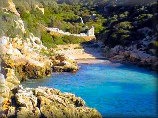
It is an "L"-shaped inlet that leads to a fine sand beach about 300 meters from the entrance. It is better protected from the winds than its neighbors. It does not have services on the beach and is at the same distance from the Binidalí housing development as it is from Cap d'En Font.
In this area are the facilities of the Bini Parratx Campsite, a summer complex managed by the Consell Insular de Menorca and intended mainly for Youth Area activities.
Cala Binissafuller:
It is a narrow inlet with a depth of about 200 meters with a small beach at the end, limited by the road that passes behind it. Just where the beach ends and four meters above it, the barranco has several small houses and even one on the beach itself.
Between this and Biniparratx, there are several coves without sand but with platforms to facilitate swimming and other aquatic activities.
To go directly to these small coves see 3
Access:
Given that each of these areas can be reached from San Luis, starting from a common section for several coves, there is a direct path to most of them, but keep in mind that once on the coast you can move to any of the others via a path that in large part follows the coastline.
How to get to the South Coast of San Luis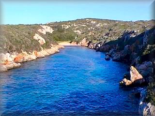
:
1 From San Luis to Punta Prima, take the exit and at the roundabout, we will take the PM702 road that leads to Alcaufar and S´Algar, less than two kilometers away. At the exit of a curve and counter-curve, there is a detour: straight ahead we go to Alcaufar and s´Algar, if we turn right, we go to Punta Prima, the starting point of this itinerary along the south coast of San Luis. Now, one kilometer later there is another fork; both paths take us there, but it is better to go left as we will go straight to the beach and the center of Punta Prima, which is five km from San Luis. If we go to the right, we will go to a roundabout in the Biniancolla area; for Punta Prima, we must turn left, in front of the large Hotel Pueblo of the Barcelo chain, and turn right to go to the beach.
2 Starting from San Luis, at the exit at the roundabout, Plaza de la Paz, take the Me 10 road to Binibeca and Biniancolla. One km later, we must take a detour to the left upon reaching the roundabout of the housing development, which is three (3) km away. To the left, we go to the beach; if we continue straight for three streets, it ends in a cross street that is the main street of the Binibeca Bell housing development; to the right is the shopping center and the Fishermen's village.
Keep in mind that this itinerary starts in Punta Prima and we reach the second point of the circuit here, so if you wish to see Punta Prima, you must continue once past the Binibeca Beach, you will pass Cala Torret and reach Punta Prima.
3 From San Luis, leaving via the Binibeca and Binissafuller road Me10, upon reaching the Binibeca junction, do not take it; we must continue. About one thousand meters further on, there is another junction, just where there are remains of the Talayotic settlement of Binissafullet, 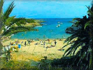 we must take the detour to the left towards the beaches. About three kilometers later we will find a fork; to the left, we go to the Binissafuller and Binibeca Bell housing developments, but if we want to see the beaches, take the right. The first will be Binissafuller, right in a dip in the road is the little cove; then you find the Cap d´en Font housing development, we will reach a roundabout; straight ahead the path has no exit, only a cul-de-sac to be able to return, but just from here a path to the barranco starts with good views and from which we can access Biniparratx Beach. It is recommended, at the roundabout, to take the right; it is the forced path to go to the other beaches. The road moves away from the coast, one and a half kilometers later in a dip to cross the barranco of Biniparratx, on the left-hand side there is a place to leave vehicles and walk down to Biniparratx beach. For Binidalí continue to the end of the path; we will find the housing development first and, turning left onto a few streets, a large roundabout with no exit, which serves as a viewpoint for the entire coast and the Binidalí cove itself.
You can click HERE and follow the following link to see the map of the area directly on the internet, using the Google Maps service.
But here you have one with the route marked and all the points of the South Coast of San Luis circuit laid out on the map to help you locate the places; click on the map to enlarge it.
Map of Menorca of the San Luis coast area

Click on the map to enlarge it.
Descriptive list of the points marked on the coast map
1) Location point of the Sa Pau Roundabout, at the exit of the village of San Luis, and where you must take the road that leads you to S´Algar, Alcaufar, and Punta Prima, the beginning of this coastal itinerary.
2) Point where you must turn right to head to the beaches.
3) It is recommended to take the left to arrive directly at the beach and shopping center of Punta Prima.
4) Punta Prima Beach, facing the Isla del Aire and next to the commercial and hotel area; at the exit of the housing development is the Son Ganxo defense tower, a bunker used for coastal surveillance by the different armies throughout the history of Menorca.
5) Cala Biniancolla, to see this area you must take the coastal path and passing the Hotel Sur Menorca, 300 m further on is Cala Biniancolla.
6) Cala Torret, has good terraces, ideal for dining on moonlit nights.
7) Binibeca Beach, with good parking areas and a pine forest to rest in, but above all a good beach and an excellent beach restaurant (chiringuito).
8) Binibeca Bell, the Fishermen's Village, commercial areas, shops, supermarket, hotel, and aparthotel.
9) Cala Binissafuller, the beach is next to the road, after a steep descent.
10 ) Cap d'en Font, almost at the end of this urbanized area, there is a small roundabout, you must take the right one, you will pass a ravine, with a path, on the left, it is visible from the road, it is the entrance to the beach of Biniparratx
Very close by is a camping area and other facilities of the complex managed by the Consell Insular de Menorca, youth area.
11 ) The next point is Binidalí
12 ) Now we must leave the coast to reach the junction of the path indicated at this point 12 and turn left to reach Cala Canutells. see Canutells circuit
To the right you go to the beach of Canutells to the left to Ses Tanques
13 ) From here, to the right to the beach of Cala Canutells and to the left to the urbanization of Ses Tanques; next to it, there are prehistoric remains of a talayotic settlement and a necropolis.
14 ) Playa de Cala Canutells, has a large parking lot and two bathing areas
15 ) Location of the urbanization of Ses Tanques and the talayotic settlement of Binicodrel, the most interesting part is the necropolis.
16 ) Once at the end of the itinerary, we can retrace our steps, but the shortest way is to return to point 12, and here instead of turning right, we will do it to the left and arrive at the town of Sant Climent, now to the right you go to Maó, passing by the airport junction and where we can take the route of the main road that will take us to any other town in Menorca, since it ends in Ciutadella.
17 ) Road that connects Cala en Porter with Sant Climent and ends in Maó, the capital of the island of Menorca.
Copyright, total or partial reproduction prohibited Photographs: Omar Mauro Banquero