


Cala Morell
Area of: Cala Morell and the beaches of La Vall
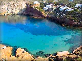 Cala Morell:
It is an elbow-shaped cove, short and at a short distance from the open sea. The beach is not very large, but in addition to the sandy area, there are some terraces to facilitate swimming; it also has a pier and a small crane for hauling out boats.
The great importance of this cove, beyond its landscape, lies in two completely different aspects. One is the fact of having a set of prehistoric caves: the Talayotic Necropolis of Cala Morell, at a very short distance from the cove, which even has privileged views of it, and it is 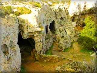 a mandatory walk; access is free. The other outstanding aspect is the curious fact that each side of the cove belongs to a different geological era, and this is appreciated at a glance even by a neophyte in the field. This only happens on the island of Menorca, as the other Balearic islands only belong to one geological era.
The area of La Vall is a very beloved and emblematic site, especially for the town of Ciutadella, as well as for those who go fishing along the 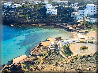 west and northwest coast of Menorca, a vital point for boats and sailors in case of being surprised by a storm, since it is one of the few inlets in a long stretch of coastline with high cliffs and whipped by the north wind, the much-feared Tramontana wind.
The residential development of Cala Morell has grown a lot in recent years and has many services and good restaurants
Algaiarens:
The unspoiled beach of Algaiarens, also called La Vall by some, which is the name of the protected area of the great valley, where the beaches of Es Tancats and the larger Algaiarens originate, in addition to the area D'Es Bot.

This “ANEI”, Natural Area of Special Interest, is therefore a protected zone, and the area encompasses from Cala Morell to La Vall, including these beaches and the entire dune complex.
The beaches are calm, unspoiled, with fine pinkish sands that, upon moving away from the sea, turn into dunes until reaching, in Es Bot, a torrent and a wetland area that separates it from the forest and the cultivated lands, right next to a small crag that separates the beaches from each other, which in turn separates the agricultural area from the north winds coming from the sea and loaded with salt spray, thus protecting the crops and forming a system used by human activity for centuries.
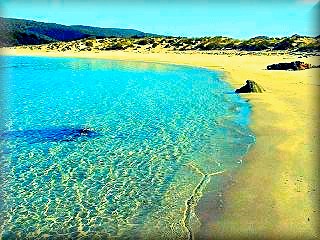
Algaiarens beach in the area of La Vall:
The beauty of Algaiarens and the entire area is immense, fully recognized by all who visit and return year after year.
The tranquility produced by its wide views relaxes the senses. The main beach, with its large dune area in the background, has, like many other beaches, a torrent that drains its fresh water into one side of the beach or submerges into the sand to enter the sea discreetly, as discreet as the casemates, shelters for militias and gunners that are found on both flanks of Algaiarens Beach. Today, one can still see the tunnels and passageways in a defensive complex built to prevent landings on the beach and thus defend the island of Menorca from new conquests.
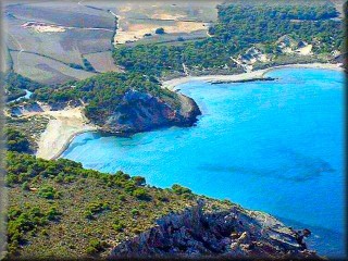
The area of La Vall has signposted paths to climb the hill and see the beaches from above.
To get to the beaches of La Vall, the last stretch of the road, which is private, has limitations for vehicle traffic, so it is usually not very crowded. Confirm the closing time of the gates if you go by car so as not to get trapped in the park. It has an area to park five minutes from the beaches; there are service areas including picnic areas. You can go on excursions on both sides of the cove; to the left and twenty minutes away is a small cove with a pebble beach of little tourist value, Cala Fontanelles, which is only used to launch boats into the sea. Passing this cove, we head towards Cala Morell.
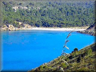 In the area to the right of the beaches of La Vall, and after passing Es Bot Beach, there are the highest cliffs in the area and on the island, which at some point reach around 150 meters with an almost vertical drop. The height of the mountains at a short distance from the coast is around 500 meters at their maximum, and Sa Falconera is 207 meters above sea level, being a privileged vantage point of the arm of land that forms the Cavalleria cape, and you can even clearly see the Cavalleria lighthouse and some of the beaches.
This stretch of the coastal path is not recommended and is not very touristy, but if we continue, the first cove we find is Sa Bombarda, from the set of Cala Cavalleria beaches, and then yes, a very, very interesting beach: 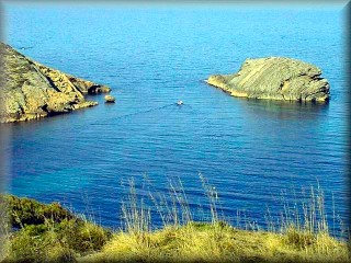 Cala Pilar.
Excursions:
The aforementioned set of caves belonging to a prehistoric settlement, which is tucked into a small ravine just to one side of the path, facing the cove a few hundred meters away; this place is essential to visit.
Access: From Ciutadella, take the exit from Ciutadella to Mahón (M1) to the Vía de Ronda roundabout; it is currently the third roundabout. Here we must take a left in the direction of Cala Morell and La Vall.
Also from Ciutadella, you can take the old road to Cala Morell that passes behind the industrial estate and enter the northern section of the Vía de Ronda, then take the road to Cala Morell and La Vall. It is well signposted. At about six km, you will find the fork: to the left, you go to Cala Morell, about three km away; to the right, La Vall, one and a half km away.
Map of the North Coast of Ciudadela
Route for the Cala Morell and Algaiarens circuit

Description of the points:
1 ) Roundabout at the junction of the Ciudadela ring road and the main road (Me 1) that connects Maó
and Ciudadela, the ends of the island of Menorca and 44 km apart
2 ) Roundabout connecting the road to Cala Morell and Algaiarens
3 ) Junction point, turn left for Cala Morell, straight for Algaiarens, La Vall
4 ) Necropolis urbanization and Cala Canutells beach.
5 ) Algaiarens beach in La Vall
6 ) Punta Nati Lighthouse
7 ) Calan Brut
The following inlets are Calan Forcat and Calan Blanes, which in case of a storm would have little or no possibility of being used for entry, so it is better to continue to the Puerto de Ciudadela or, in the future, the Loading Pier in the area of Cala Santadrià
Photographs: Omar Mauro Banquero